When you get into the world of drones, there’s a lot to learn at every turn. You also have to make decisions about what kind of technology and methods to utilize, which will then influence the type of drone to buy.
With all the choices and uses of drones, it can be confusing to determine what you need to achieve certain goals. Among these are the concepts of drone LiDAR and drone photogrammetry. Some people might not know what these mean in the first place, let alone differentiating between the two. So, what kind of technology should we be using for different projects? Discussing both of them in some details will hopefully help us answer this question.
Let’s discuss them in detail and see which one you need for your hobby, career, or project.
Brief definitions
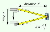
LiDAR stands for Light Detection and Ranging. This is a kind of sensor technology that uses light energy from lasers. These lasers scan the landscape and give accurate measurements of variable distances. At the end of the scan, you get a decent amount of elevation data, which is then used for producing high-resolution maps. The data is also good for making 3D models with a drone, both of man-made objects like buildings or natural objects such as mountains. The following image shows how these lasers give us measurements:
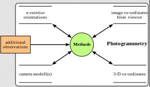
Drone photogrammetry refers to the practise of getting physical data from pictures in 2D. These photos are usually aerial images taken by drones. A lot of GIS and surveying professionals make use of drone photogrammetry and GPA data to make models and maps in 3D. These are then utilized for use in the mining, waste management, and construction industries to aggregate workflows. The following data model of photogrammetry will hopefully clear things up further:
Advantages and Disadvantages of LiDAR
The working of LiDAR, which is also sometimes called 3D laser scanning, works through sending light pulses to the surface of the earth of some object on it. By noting the time it takes for the light to reflect back, we get an accurate point of the place where the laser hits.
LiDAR units are able to blast several thousand pulses of light per second, which helps in building a visual of the object in question. Afterward, this data can be useful in creating 3D point clouds, giving accurate visuals regarding the terrain of an area, its features, and general topography.
Drone LiDAR is now a very useful tool for those who work in aerial surveying. It has several applications, including construction, agriculture, and forestry.
Advantages:
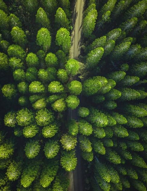
- When we use LiDAR, we get a better performance for some missions, especially when covering areas with high vegetation. This is because the light pulses can get through small gaps between the foliage and reach the ground
- LiDAR is also the better option when it comes to places with low light, a night mission, or when there’s a significant amount of cloud cover, dust, etc.
- With the high-density point sampling as well as the direct measurements, LiDAR is better for capturing and measuring small objects and narrow ways; these include objects with sharp features, pipelines, and cables.
Disadvantages:
- Accessibility is where LiDAR usually falls short as compared to photogrammetry. LiDAR is a bit complex, requiring a lot of understanding, and can increase the risk of making an error. Only experienced professionals can utilize this tech properly. However, further developments and new offerings are now enabling less experienced drone users to make use of LiDAR. The DJI L1 is a good example of how LiDAR workflow can be simplified.
- Can be a bit unspecific regarding features and surfaces with fine details. This could mean that the viewer is not really sure of what they are seeing.
- Certain point clouds in LiDAR might only take the abstract away from its resulting data sets.
- LiDAR sensors for the lasers are usually large, which means we need larger drones to carry them. This resulted in a higher initial cost. Again, though, new developments have managed to shorten the cost gap as well. Today, we have more compact and cost-effective models for LiDAR on the market as well.
Advantages and Disadvantages of Photogrammetry
In photogrammetry, we get to capture some high-res photos in order to recreate the area we are surveying. By processing and stitching these images together, we can make very realistic and to-scale 3D models of real objects or 2D maps.
The applications of photogrammetry include mapping of crime scenes, marketing, stockpile calculations, stockpile measurements, project management, building surveys, and topographical mapping.
Advantages:
- A more straightforward method for data surveying than LiDAR. It gives us information on what height is the best for ground sample distance, the image overlap rate we want to get the most accurate 3D models and maps, etc.
- Easier to use, so anyone using a good camera drone can make accurate maps or models for their organization.
- The models and maps created through photogrammetry have a lot of real images stitched together. The result is immediately readable and relatable, so one can share it among teams for proper and quick understanding.
- With high-res imagery, photogrammetry results give us visual details of every site feature. Crucial for tracking changes and aerial visualization, photogrammetry is perfect for joining the progress on any job site.
- Photogrammetry uses images taken from a drone’s camera. This makes it a more affordable option.
Disadvantages:
- Photogrammetry is not as effective or accurate as LiDAR when it comes to places with a lot of vegetation. The small obstacles like leaves, twigs, and branches, will prevent photos from giving a realistic depiction of the terrain underneath. If we want to create a DSM or Digital Surface Model, which has the surface of the earth and all the things on it, photogrammetry is almost the same as LiDAR.
- Not suitable for places with low light or in evening light, with dust, or cloud cover
- Will not be very good at capturing or measuring objects with sharp edges, or those that are very small and narrow.
Overall, it seems like LiDAR is a major part of the way that drones are revolutionizing the agriculture industry. Photogrammetry might be better for making useful maps and models, and is more accessible for a large number of drone owners due to its relatively lower price. However, with more innovations each day, LiDAR is likely to become much more accessible in its cost as well as applications.
Which One to Use and When?
Not every industry and application requires a lot of accuracy. However, drone surveying is one aspect that needs reliable, accurate results. Photogrammetry and LiDAR can be almost equal here if they are carried out in the correct manner. While the gap between the two is slowly closing, there are still certain applications where you should choose one over the other. Let’s have a look at which method to consider for a certain job:
When to use LiDAR?
We might prefer using LiDAR for our drones for:
- Mapping below any tree canopy
- Mapping in mine sites
- Any area with a lot of instructions
- Modelling roof edges
- Modelling transmission lines or pipes
- Mapping fields with a lot of rocks
The reason for this is that LiDAR is still best equipped for bypassing blockages or obstacles and generating accurate elevation models. With photogrammetry at present, there are likely to be blunders when making digital elevation maps. This is because it relies on images. If a bush or tree is standing in the way of a point in one image but not visible from another angle, this can confuse the algorithms, resulting in inaccurate modes. Photogrammetry might still be good in mapping elevations, but only when the ground in question is flat and similar from every angle.
LiDAR, on the other hand, measures through several data points, each taking a measurement from the rays that hit the surface. In short, for small objects and a high number of instructions, LiDAR still remains on top for now.
When to Use Drone Photogrammetry?
The following applications will be ideal for photogrammetry:
- Imaging earth works projects
- Mapping mine sites
- Mapping any area without major obstructions like trees, equipment, or buildings
- Small mapping missions
In the cases above, photogrammetry is the more logical option. The lower cost is certainly one of the reasons, but there’s also the fact that its drones are lighter and speedier. If LiDAR isn’t a requirement, all you have to do is add a camera to your existing drone. The difference could mean saving several thousand dollars.
When to Use Both?
There are also some instances where one might use both these methods for the best overall result. For instance, you may require modelling through LiDAR, but also use high-resolution data that comes from photogrammetry. Aerial LiDAR might fall short in this aspect, so we can supplement using imagery from drone photogrammetry for the ideal output.
The final answer about using LiDAR or photogrammetry will depend on the kind of business or project you hope to achieve with these methods. Both are useful and powerful options, but one also has to take the time to learn them correctly.
The following table will summarize the comparisons between LiDAR and photogrammetry for drones:
Photogrammetry | LiDAR | |
Accuracy Level | +/- 50mm (absolute) | +/- 50mm (absolute) |
Cost of System | Less than $10,000 including a drone equipped with RTK/PPK | More than $100,000 for the sensor and IMU along with other equipment |
Ideal Applications |
|
|
Conclusion
A lot of the technical advice and comparisons we make today might not be applicable for very long. LiDAR technology is seeing a lot of development and changes as we speak. It might soon be possible to get lighter, more compact models with LiDAR that are also more accurate than the models we have now. In the near future, these models will probably be in higher demand. If we supplement them with proper cameras, they can be the most complete kit on any drone. For now, though, we have to work with what’s best for the mission or application at hand.
